


















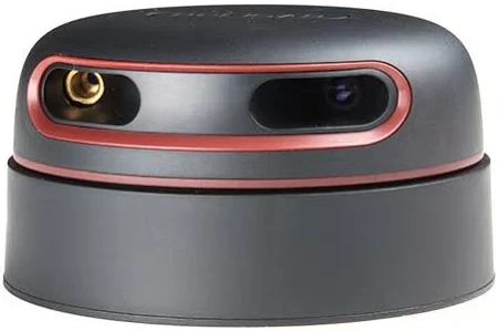
The RPLIDAR A2 is a 360° 2D laser scanner (LiDAR) designed for high-performance mapping, navigation, and obstacle detection in research, robotics, and IoT applications. It uses triangulation ranging technology to deliver precise distance measurements in all directions, making it suitable for SLAM (Simultaneous Localization and Mapping), autonomous navigation, and robotics research.
With a detection range of up to 12 meters and a scanning frequency of 10–15 Hz, the RPLIDAR A2 provides real-time, high-resolution 2D mapping. Its lightweight design and low power consumption make it ideal for both academic research and embedded IoT/robotics projects.
Technical Specifications:
-
Scan Mode: 360° 2D scanning (rotational)
-
Detection Range: 0.15 m – 12 m
-
Accuracy: ±1% (within 1.5–10 m)
-
Sampling Rate: 4,000 – 8,000 samples per second
-
Scan Frequency: 10–15 Hz (configurable)
-
Angular Resolution: 0.45° – 1.35° (depending on mode)
-
Field of View: 360° full coverage
-
Interface: UART/USB adapter (3.3V TTL serial)
-
Operating Voltage: 5V DC
-
Current Consumption: 400–500 mA (typical)
-
Dimensions: ~76 mm × 70 mm × 41 mm
-
Weight: ~190 g
Features:
-
Full 360° omnidirectional laser scanning for SLAM and navigation
-
High-speed sampling (up to 8,000 samples/sec) for accurate mapping
-
Compact, lightweight, and low-power design for mobile robots and drones
-
Strong SDK and ROS (Robot Operating System) support for research integration
-
Compatible with Arduino, Raspberry Pi, NVIDIA Jetson, and embedded controllers
Common Research & IoT Use Cases:
-
Robotics: SLAM, autonomous navigation, mapping, and obstacle avoidance
-
IoT & Smart Systems: Environment mapping and presence detection
-
UAVs & Drones: Altitude and obstacle detection in controlled environments
-
Academic Research: Mobile robot prototyping, AI navigation algorithms, multi-robot systems
-
Industrial Applications: AGVs (Automated Guided Vehicles), warehouse robots, and service robotics
The RPLIDAR A2 is widely used in robotics research labs and IoT prototyping because it combines 360° scanning, affordable cost, and ROS compatibility, enabling rapid deployment in advanced navigation and mapping projects.